Canada has launched a scientific mission to map the seabed surrounding the North Pole, aimed at claiming the area.
The Canadian government said in a statement issued on Friday that two ice-breakers will be sent to the Arctic waters to gather scientific information to support a plan to extend Canadian territory up to the North Pole.
The coast guard vessel Terry Fox reportedly set sail from St. John’s, the regional capital of the eastern province of Newfoundland and Labrador on Friday, one day ahead of the ice-breaker CCGS Louis S. St. Laurent, which will “collect high-quality data” about the shape and composition of the seabed.
“Our government is committing the resources necessary to ensure that Canada secures international recognition of the full extent of its continental shelf, including the North Pole,” said Canada’s Foreign Affairs Minister John Baird.
The mission comes after Ottawa filed a UN application in December 2013, seeking to vastly expand its Atlantic sea boundary.
Canada is not the only country seeking to claim the area. Russia and Denmark are also seeking scientific proof that the area is an underwater extension of their continental shelf.
If Canada’s claim over the territory is accepted by the UN body, its share of the potentially oil/gas-rich region would grow dramatically. The US Geological Survey estimated previously that the area could hold 13 percent of the world’s undiscovered oil and up to 30 percent of its hidden natural gas reserves.
RELATED ARTICLES
- After Fooling the People to Reelect Putin, Russia now announces More Cannon Fodder Mobilizations
- Russia Fires Barrage of North Korean Missiles at Kyiv After US Visit
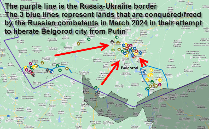
- Ex-Wagner fighters Join Free Russia Army's Battle to Liberate Russia from Putin Occupation
- Hungary Becomes First EU Country to Congratulate Putin for Winning the 'Elections'
- UN says 70% of Gaza's population faces Catastrophic Hunger